
The fit and acclimatized will enjoy this very long but varied day hike alternatively take your time and take two days. There are ample opportunities for discourse with locals before a zigzagging climb through beautiful old gnarled polylepis forest leads to a fantastic viewpoint of milky-green Laguna Lejiacocha and Nevado Copa’s fluted west face.
After negotiating the maze of trails in the fields around Vicos, the path to the lake is good and clear, as this is the route used by mountaineers to climb Nevado Copa. Those with sufficient acclimatization could camp near the lake, splitting the route into two more manageable days.
Start & End Vicos
Distance 23km/14 miles
Trekking time 9 hours
Vertical climb 1700m/5600ft
Max altitude 4640m/15,200ft
Navigation 2 Some navigation skills required. Sections with only faint trails, or short stretches with no path.
Terrain 1 Walking on paths which are in decent condition and not overly steep.
Timing and getting to and from the trailhead
This is a long day walk, so leave very early. Take a Caraz/Carhuaz combi from Huaraz and alight at Paradero Chancos (30 minutes, S/.3) in Marcará. Colectivos for Vicos (via Chancos) leave regularly from here (10 minutes, S/.1.50). Returning, colectivos from Vicos to Marcará run until dusk.
Preparations
The walk has a significant vertical height gain, so you should be well acclimatized before attempting it. Part of the route is within PNH, but there are no checkpoints. Bring all the supplies you need as there are no shops after Vicos. If you have time, it’s well worth going for a dip at the hot baths (06:00-20:00) in Chancos after your walk.
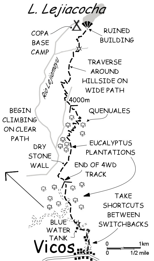
Vicos – Laguna Lejiacocha – Vicos
From the plaza in Vicos, take the road to the L/N of the church, passing a large building with a curved roof. Climb up the hillside behind, following the road or shortcuts. After 40 minutes of height gain, reach a right-hand bend in the road with a circular blue building/water tank just above. Leave the road here, taking the path to the R/E of the building that descends to a bridge (5 minutes).
Five minutes after, leave the wide, traversing path for a large, rough footpath which climbs up R/NE, through eucalyptus woods. Twenty minutes later go straight at a junction, on a 4WD track, and continue straight at two further junctions, still climbing through woods. After this third junction, the 4WD track crosses a water channel and continues climbing. Round a ridge and leave the eucalyptus grove, after which the 4WD track becomes a walking path (30 minutes) which follows a small valley.
In 10 minutes reach another eucalyptus plantation and slice straight through. From the far end of the plantation (10 minutes) a path, which soon becomes wide, leads off up the hill in zigzags, ascending through queñual forest. After 1h30 cross a stream – the most reliable water source on this part of the climb – then leave the polylepis forest for the remaining 2- to 3-hour climb to the lake. Returning, it’s 3h-3h30 back to Vicos.
